
Florida’s inlets have gotten a lot of attention recently even beyond the recreational boating world thanks to the popularity of online videos, most of which show boats transiting (or failing to transit) Haulover Inlet with its standing waves and chaotic traffic. In fact, there are around 20 inlets on Florida’s Atlantic Coast, depending on how you count.
Contents
What is an Inlet?
Generally speaking, an inlet is passage through a barrier island connecting the open ocean with an inland waterway. On the east coast of Florida, most connect the Atlantic to the Intracoastal Waterway or one of several large lagoons. Many are completely manmade. Others existed historically but have been “improved” for easier navigation with jetties and dredging. And a few are still more or less unaltered from their natural state.
Here are all of them, ranked not in numerical order but grouped into “tiers,” ranging from major shipping channels that are 40’ deep and a mile wide to sketchy, winding routes through shifting sandbars known only by hardcore locals.
Tier Zero: Always a Cakewalk
These are wide, deep inlets with few hazards that are maintained for use by cargo, cruise and military ships. In any inlet, you can encounter strong currents, steep seas and heavy traffic, but these are passable in almost any conditions.
St. Marys Entrance
Passing between Jekyll Island, Georgia, to the north and Amelia Island, Florida, to the south, St. Marys Entrance is wide, deep and well marked. Navy submarines frequently transit the inlet on their way to or from Submarine Base Kings Bay.
St. Johns Entrance
Heavily used by cargo, cruise and military ships, the entrance to the St. Johns River near Mayport, Florida, is at least 30 feet deep and protected by long jetties on both north and south.
Port Canaveral
Another Navy hub and the second-busiest cruise ship port in the world, Port Canaveral isn’t even truly an inlet. Unless the Canaveral Lock is opened to allow passage into the Banana River, Port Canaveral is really just a harbor.

Lake Worth Inlet
Manmade Lake Worth Inlet (aka Palm Beach Inlet) is a wide, well-protected, straightforward inlet passable by cargo and cruise ships.
Port Everglades
The world’s third-busiest cruise ship port as well as a major shipping hub, Port Everglades in Fort Lauderdale is accessed via deep, wide, manmade channel.
Government Cut
A manmade channel between Miami Beach and Fisher Island, Government Cut provides deepwater access to the Port of Miami for cargo and cruise ships and to northern Biscayne Bay for thousands of recreational boats a day.

Tier One: Easy Most of the Time
These are inlets that can get dicey in certain conditions but are heavily used by recreational boaters and usually aren’t too challenging. You’ll only encounter breaking waves in the worst conditions, and there are few or no “complicating factors” like doglegs in the channel. The channels can shift over time but are typically marked with buoys.
St. Augustine Inlet
Like most East Coast inlets, St. Augustine can get rough with a strong outgoing tide and an onshore wind, but the channel is wide, deep (15 - 20’) and well-marked with buoys. The biggest hazard is typically heavy recreational boat traffic.
Ponce de Leon Inlet
Usually referred to simply as “Ponce Inlet,” this entrance between Port Orange and New Smyrna Beach rarely presents a problem. The channel is dredged to 12 feet or more and well marked with buoys. Steep waves can form near the end of the jetty on an outgoing tide, and fishing boats often anchor or drift along the north jetty, obstructing traffic.

Ft. Pierce Inlet
Almost a “Tier Zero,” Ft. Pierce Inlet is wide, straight, protected by north and south jetties, and 20 or more feet deep. Outgoing tides and onshore winds can create steep seas — just as they can at any inlet — but other than that, there’s little to worry about.
St. Lucie Inlet
Just 17 miles south of Ft. Pierce Inlet via the Intracoastal, St. Lucie inlet gets rougher faster with any kind of easterly wind. Still, the only issue is steep, confused seas. Sandbars and oyster bars in the vicinity of “The Crossroads,” where the St. Lucie River meets the Intracoastal, present a bigger hazard than the inlet itself.
Hillsboro Inlet
Hillsboro Inlet in Pompano Beach has claimed a lot of boats over the years, but mainly when boaters run aground trying to cut between the inner end of the north jetty and the beach to the north or don’t pay attention to the markers and hit the reef to the south of the channel. Otherwise, Hillsboro is reasonably tame, except that a strong outgoing tide and an east or southeast breeze can create steep, confused seas.

Hillsboro Inlet in Pompano Beach has claimed a lot of boats over the years, but mainly when boaters run aground trying to cut between the inner end of the north jetty.
Tier Two: Pretty Rough Pretty Often
These two inlets have gained a lot of notoriety on social media over the last few years for their steep standing waves and breakers, which make for entertaining videos. It doesn’t hurt either that both are in densely populated areas and have great “spectating” from the jetties. Aside from rough water, though, they’re fairly straightforward and used by hundreds of boats a day.
Boca Raton Inlet
The main hazard at Boca Inlet is breaking waves over the shallow bar (often only 4 - 5’ deep) just beyond the jetties. Often, the only way around the breakers is through them, so this is no place for bow riders or low-freeboard boats except in the calmest conditions. Because it’s so shallow, Boca can have hazardous waves regardless of tide and wind.
The main hazard at Boca Inlet is breaking waves over the shallow bar just beyond the jetties. Often, the only way around the breakers is through them.
All it takes is a sizable swell to create breaking waves all the way across the mouth. There’s also frequent shoaling along the north side of the channel, forcing boats into a narrow area as they make the turn east toward the exit.
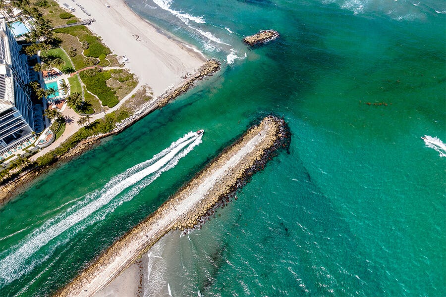
Haulover Inlet
Technically called Baker’s Haulover Inlet, this narrow, manmade cut at the north end of Bal Harbour has become a household name among boaters all over the country thanks to an unending stream of online videos showing boats and boaters of every description navigating its now-famous standing waves.

Unlike Boca, Haulover isn’t particularly shallow, so it’s usually fairly tame as long as you don’t have an outgoing tide opposing an onshore wind.
Unlike Boca, Haulover isn’t particularly shallow (around 12 - 14’ in the channel), so it’s usually fairly tame as long as you don’t have an outgoing tide opposing an onshore wind. Almost as big a hazard as the standing waves is simply the craziness of the whole scene. Jet skiers zig-zag everywhere, offshore go-fast boats roll through at 50 mph, inexperienced boaters lose their nerve and make sudden U-turns mid-channel, kayakers and paddle boarders further muck things up, and many boaters are paying more attention to the video cameras on the jetties and the half-dozen drones buzzing overhead than to where they’re going.
Tier Three: Commonly Used but Dangerous
These are the worst three “improved” inlets in Florida. Not only do they get very rough with outgoing tides and onshore winds, but they also have additional complicating factors beyond just waves. Many recreational boaters transit all of these inlets every day, but you better know what you’re doing. And remember that once you’re in one of these three, you’re committed. There’s no turning around.
Sebastian Inlet
Probably the least scary of these three, Sebastian Inlet is also the most remote, situated in a relatively undeveloped part of the barrier island between Melbourne and Vero Beach.
Sebastian’s main claim to fame is the sheer velocity and turbulence of its currents, which reportedly reach 10 knots.

With the exception of the Canaveral Lock, which doesn’t really count, the closest inlets to Sebastian are Ponce, roughly 80 miles to the north, and Ft. Pierce, about 25 miles to the south. That translates to an incredible volume of water racing through Sebastian with every tide.
Sebastian’s main claim to fame is the sheer velocity and turbulence of its currents, which reportedly reach 10 knots.
Set that kind of current up against an onshore breeze or swell, and you get something akin to Class IV whitewater — standing, breaking waves, whirlpools, holes and cross-currents. Then, for good measure, add a long jetty on the north side packed with territorial fishermen well known for casting lead and lures at boats they deem too close to the rocks. On top of that, the channel is narrow, constantly shifting and completely unmarked. Oh, and just to the south of the inlet is an offshore sandbar called “Monster Hole” that breaks when the swell is right. You’ll want to avoid that.
Jupiter Inlet
Generally recognized as the most dangerous inlet in Florida, Jupiter has it all: a narrow, unmarked channel, powerful currents, and standing waves when outgoing tides meet onshore winds. But what really puts it on the map is a shallow bar (around 5’) just outside that breaks all the way across with any swell to speak of.
Smaller boats can sometimes run to the south along the beach and inside the bar watching for a window to sneak across, but there’s no getting around the bar. With an east wind and/or a significant swell, getting out of Jupiter means going through breaking waves. Those breakers have rolled a lot of boats over the years, and not just small ones.
Boynton Inlet
Just 130 feet wide with vertical concrete walls on both sides, Boynton is more a sluice than an inlet. Waves and boat wakes refract off the walls, creating washing machine conditions even in calm weather. With an outgoing tide, nasty standing waves add to the fun. On the exit, the channel doglegs sharply to the right, obscuring the ocean until the last minute.

Just 130 feet wide with vertical concrete walls on both sides, Boynton is more a sluice than an inlet. Waves and boat wakes refract off the walls, creating washing machine conditions even in calm weather.
When the tide is ebbing, the current slams into that north wall like a river on the outside of a bend, requiring boaters to make a hard turn to starboard across the current. Powerful, swirling eddies form around the end of the south wall. Meeting another boat coming the other way here can be sketchy. Once you clear the walls, with any kind of a swell or easterly wind, you’re immediately faced with breaking waves. The route through the shoals changes over time but is often as shallow as 4’ or so.
Tier 4: As Nature Intended
The last three inlets on Florida’s east coast — Nassau Sound and Fort George Inlet between Mayport and Amelia Island, and Matanzas Inlet between St. Augustine and Daytona Beach — remain largely as they always have been.
They are natural inlets, not dredged, not marked and not stabilized or protected by jetties. All are shallow and sandy with braided, shifting channels and frequently breaking waves.
All of them are also transited regularly by recreational boaters, but they truly require the proverbial “local knowledge.”
Nassau Sound, Fort George Inlet and Matanzas Inlet are natural inlets, not dredged, not marked and not stabilized or protected by jetties.