Tide Chart Basics
January 05, 2024 9 min read

If you use your boat in saltwater, tidal fluctuations can have a major impact on your activities. Many a lower unit has been lost because an extreme low tide exposed a submerged hazard that the owner drove over safely dozens of times before. Opposing wind and tide combinations can turn a normally placid waterway into a chaotic and dangerous gauntlet. Understanding what the tide will do during your day on the water is an essential part of keeping yourself, your passengers and your boat safe.
Contents
Information on a Tide Chart
There’s more to tide charts than timing, and while some recent mobile apps can simplify them, translating what you see on a tide chart to what you will see on the water takes experience. However, you can shorten your learning curve enormously by understanding a few key principles and knowing what to pay particular attention to.

Many boaters only glance at a tide chart to know the timing of the high and low tides, but a tide chart is loaded with information that can give you a clear picture of what to expect for the day. Whether you are a fisherman or just planning a day on a sandbar, knowing what the water will do helps you make the most of your day. Beyond just the timing of the tides, there are some specific things to pay attention to.
Tidal Height
Most tide charts will show the height of the high and low tides, and these heights will vary based on the moon phase. The heights listed are relative to the “mean lower low water” for the area, which represents the average daily “lowest” low water observed in an area over the prior 19-month period. A low tide at “0” feet would represent that average “lower low water” mark, and a negative low tide would represent a lower-than-lowest-average tide. If you are going to be in an area you are unfamiliar with, negative tides should be taken very seriously, as these could expose unmarked hazards and could impact your ability to safely navigate to your destination.
Tidal Fluctuation and the Rule of 12ths
The larger the distance between high and low tide, the stronger the currents will be and the faster the changes in depth will occur. If your activity will involve a depth-sensitive area, such as enjoying a day at the sandbar or fishing a shallow marsh, these larger tide swings require particular attention and planning.
It is important to know that tides move at their fastest around mid-tide and are slowest around the high and low.
It is important to know that tides move at their fastest around mid-tide and are slowest around the high and low. The “rule of 12ths” is a useful guideline to understand how much the water level will change throughout a tide cycle. The rule divides the total tidal depth change in a typical 6 hour cycle into 12ths, and then applies a “1-2-3-3-2-1” formula to it. In the first hour, the tide will change 1/12th of the total distance. In the second hour, it will change 2/12ths of the total distance. In the third hour and fourth hour, it will change 3/12ths, then 2/12ths in the 5 hour, and 1/12th in the 6th hour.
A Closer Look
If that seems confusing, let’s look at a typical East Coast example. Consider a situation where the tidal fluctuation between high and low tide will be 6 feet. In most areas, the tidal period between high and low tide is roughly 6 hours. That means that the water depth will change 1/12th of 6 feet (half a foot) in the first hour after high tide. That is hardly noticeable.
In the second hour after high tide, the water level will drop 2/12ths (1 foot), which would be more noticeable. In the third and fourth hour after high tide, the water level will drop 3/12ths, or one-and-a-half feet per hour, which would be hard to miss.
The last two hours follow the first two hours in reverse — 1 foot, and then finally the last half foot in the final hour. While a foot and a half may not seem like a lot of depth, keep in mind that represents vertical distance. With that vertical change of depth, the actual waterline on the sandbar you are enjoying can move out twenty yards or more, depending on the contours.
Moon Phase
Most charts show moon phases and this can be incredibly helpful in predicting tide behavior. Both the sun and the moon drive our tides, but of the two, the moon has the bigger impact. Moon phase helps us understand how much these two forces are working together.
During both “new moon” and “full moon” phases, the sun and moon are aligned in a manner that maximizes tidal fluctuations.
During both “new moon” and “full moon” phases, the sun and moon are aligned in a manner that maximizes tidal fluctuations.
During a new moon phase, the sun and moon are on the same side of the Earth, both pulling together.
During a full moon, the moon and sun are on opposite sides of the Earth, again, maximizing the daily tidal fluctuations without interference from each other.
During both of these phases, the alignment of the gravitational forces will cause the most extreme tidal fluctuations.
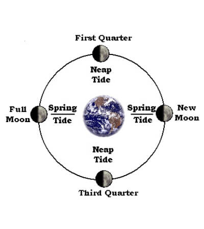
Partial moon phases represent times when the sun and moon are aligned in a manner where their gravitational forces interfere with each other, resulting in smaller tidal fluctuations. A quarter-moon occurs when the sun and moon are perpendicular to each other relative to the Earth, and tides during these times of the lunar month will be the smallest.
Other Factors that Affect Tides
Tide charts only represent the predicted tidal movements based on moon phase, but the reality you experience on the water can be vastly different than what the chart might suggest. To get an accurate understanding of what the tide will actually do, you need to look at the other dynamics that will influence tidal behavior. Geography, wind direction, wind speed and even barometric pressure can all have a significant impact on what all that water will actually do, and when it will do it. When planning your day, take a look at these factors:

Tide charts only represent the predicted tidal movements based on moon phase, but the reality you experience on the water can be vastly different than what the chart might suggest.
Geographic Location
Although the principles that drive tides are the same everywhere, the impact they have on tidal fluctuations can be vastly different based on where you live.
Tides along continental coastlines tend to be higher since water “builds up” along a larger barrier as it tries to chase the gravitational pull of the sun and moon. Tides on smaller land masses, like islands, can be significantly smaller since water can flow around them.

Coastline Structure and Contour
On many parts of the Pacific and Atlantic coast lines, tides are relatively predictable. High and low tides are roughly six hours apart, and each day, the high and low tide times move roughly an hour forward. In these situations, if you know the tides on a Wednesday, you can easily estimate what they will be on a Friday.
However, even along these same coastlines, the funneling effect of some bays can magnify the tidal fluctuation, whereas the constricting effect of other geography can minimize it. Constricted bodies of water, like the Gulf of Mexico, will have tidal changes that are much more erratic. In these locations, it is difficult to guess what they will be without reviewing a tide chart. If you are planning a trip to a destination that you aren’t familiar with, it is wise to do some research to understand how much to expect the tide to fluctuate.
The funneling effect of some bays can magnify the tidal fluctuation, whereas the constricting effect of other geography can minimize it.
Keep in mind, as well, that the topography of your destination can influence how dramatic the tidal fluctuations can appear. Along steep rocky shorelines, the tidal fluctuations will be less obvious, because the change is primarily vertical. In shallower areas, however, the landscape can look vastly different between high and low tides. The horizontal movement of the waterline can often be much more significant than the vertical depth change. Water that appears wide open at high tide can suddenly be reduced to tight, winding channels on a low spring tide.
Distance from Primary Body of Water
A common tactic of fishermen is to “chase the tide,” jumping from one spot to another to catch the same, specific phase of the tide over and over again. This is most common in estuaries and tidal rivers, where current flow is constricted. In these situations, the tidal phases can be hours later the further away you are from the coastline. It is completely possible to fish a high or low tide for several hours by working your way farther and farther away from the mouth of a river or deeper into a bay.
It’s possible to fish a high or low tide for several hours by working your way farther and farther away from the mouth of a river or deeper into a bay.
Wind
Wind direction and speed can have a significant impact on both the height and actual timing of tidal fluctuations. Onshore winds can stack more water into a high tide, raising the water level even higher, and at the same time, delay the tide moving back out. Alternatively, an offshore wind can lower and accelerate a high tide, and make the low even lower.
Even in bodies of water with negligible tidal fluctuations, the wind can raise and lower water levels by several feet.
In areas with stronger tidal current, an opposing wind/tide situation can create significant short period wave action, even in areas that are normally calm. Rivers, inlets and other areas where currents are constricted can suddenly “stand up” after a tide change if the water begins moving in opposite directions from the wind, and these situations can become dangerous even for the average sized bay boat.
Keep in mind that, even in bodies of water with negligible tidal fluctuations, such as the Great Lakes, the Pamlico Sound (North Carolina) and Laguna Madre (Texas), the wind can raise and lower water levels by several feet. A sustained, strong wind from the same direction can dramatically impact water levels. In these locations, it is equally important to know what the wind has been doing over the last several days as it is to know what the wind will do on the day of your adventure.
Atmospheric Pressure
Some water-related activities are dependent on very specific tidal conditions. Whether that is chasing redfish on a “tailing tide” or exploring exposed tidal flats on particularly low tides, atmospheric pressure can dictate whether the conditions you need will actually take place. The high-pressure systems that produce cloudless, sunny days can significantly lower the actual tide height, whereas those stormy low-pressure systems can drive water higher.
Weather Wisdom
If your boating adventures involve large bodies of water, you are at the mercy of many factors that can influence the water’s behavior. Water level, currents and wave action can be heavily influenced by tides and weather. Understanding how to read a tide chart and knowing how to layer in weather-related factors can help you plan your boating adventure in a manner that keeps you, your passengers and your vessel in good shape.